


The Boca Beacon’s Hurricane Watch

This running report was created for readers to be able to find up-to-date information regarding 2022 tropical storms and hurricanes. You can see real time updates by scrolling down to the dates and times listed for each entry (after the list of things you should know about Boca Grande storm information.)
You can also find up-to-the-minute storm information for this area on our Facebook page, facebook.com/bocabeacon. See the link below for Charlotte County shelter locations. All locations are pet-friendly with stipulations (please read the article just below for more).
Storm information to know about Gasparilla Island:
1. The Boca Grande Causeway does NOT close to CAR traffic. It closes to BOAT traffic when winds reach sustained 40 mph. That means if you are in a boat and the winds are 40 mph or higher, you aren’t coming under the Boca Grande Causeway swing bridge.
Officials will sometimes close the bridge to general traffic after a storm has passed and officials have declared it unsafe to come on the island.
2. Hang tags are an important part of gaining entry to the island in the above situation. If officials are posted at the bridge (law enforcement, in other words) and telling you that general traffic cannot come onto the island, having a hurricane hang tag issued by the Boca Grande Fire Department is optimal.
In other words, if you don’t have a hang tag and need to get on the island you had better come with some pretty good credentials that show you’re supposed to be out here.
They normally do not issue hurricane hang tags 48 hours prior to the predicted time a storm is supposed to hit this area, so make arrangements ASAP. Here is more information: https://bocabeacon.com/business-owners-residents-make-sure-you-are-hurricane-ready/
3. If you are staying on the island during a hurricane, the Boca Grande Fire Department asks that you call and let them know where you will be staying, how many people are with you, what their names are and a number for next of kin. This will be useful information in the event body identification is necessary.
4. Other than going to bocabeacon.com or here to this Facebook page your sources for island information during a hurricane can be found by searching “BGFD” on your Apple or Android phone. This will take you to the Boca Grande Fire Department app. The Fire Department is the island Emergency Operations Center and they will provide valuable information for the island during a storm. The Gasparilla Island Conservation and Improvement Association has a mailing list for storm information. Click on this link to sign up: https://thegicia.us16.list-manage.com/track/click?u=554dd2328365a0ff633e28b49&id=a0ec42c801&e=e33c04a4c3
5. We will stay online and on the ground as long as there is a threat, as well as afterward. If you want to see a specific street, property, marina, etc., just message us and we will do our best to get out there and send you photos. If you need someone checked on, message us. Anything you need, let us know. If there is no internet signal for us to transmit information on, you can call (941) 276-8646 to reach the editor, Marcy.
Monday, Sept. 26, 2330 EDT
Still not great news about Ian. He is just meeting up with Cuba in a little bit and will cross over quickly. That is when the meat of the matter will begin to show itself, as the storm will be unencumbered and appears to be ready to rock and roll.
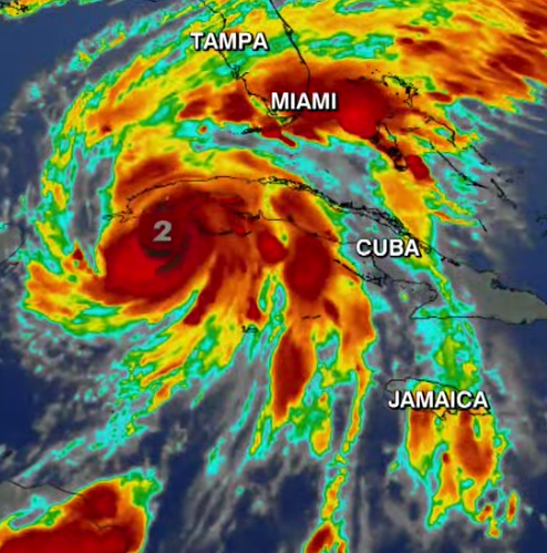
He is currently traveling at 13 mph WNW, with a slight turn toward the north coming within the next eight to 12 hours. Right now he is a Cat 2 hurricane but the expectation is that he will strengthen once out in open, very warm water. As of tonight it appears he will be heading our way.
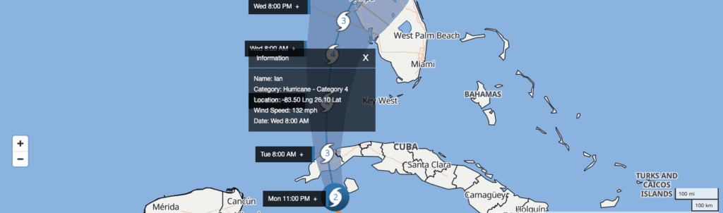
With that being said, and keep in mind this is still a very general guess because things can change so quickly, he would be a Cat 4 when he was in the Gulf just to the south of us, heading up toward Tampa with winds of 132 mph. Now I have never claimed to be Magellan, but if you look at the little key down on the bottom right that shows the distance differential in miles and you grab your little piece of paper and mark that out, then drag that over to the storm vs where we sit, Ian is well over 100 miles out.
Again, I could be wrong on that. We will definitely have the weather and some water problems.
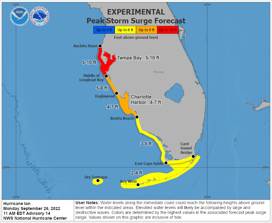
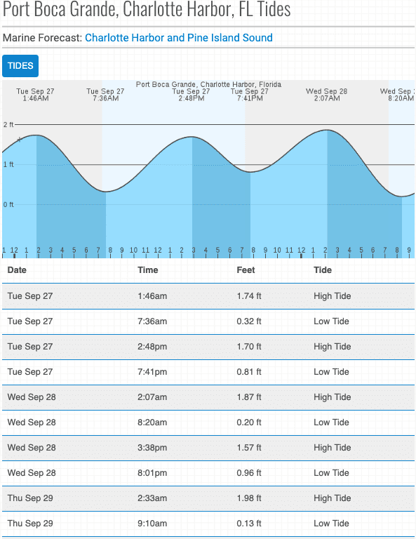
Here’s some more important information. Important tides in the next 48 hours are these:
Tuesday, 0146, high tide
Tuesday, 0736, low tide
Tuesday, 1428, high tide
Tuesday, 1971, low tide;
Wednesday, 0207, high tide
Wednesday, 0820, low tide
Wednesday, 1538, high tide
Wednesday, 2001, low tide
These times are going to be very significant markers if you live coastally or have to check on boats. You can see the graphic for more tides.
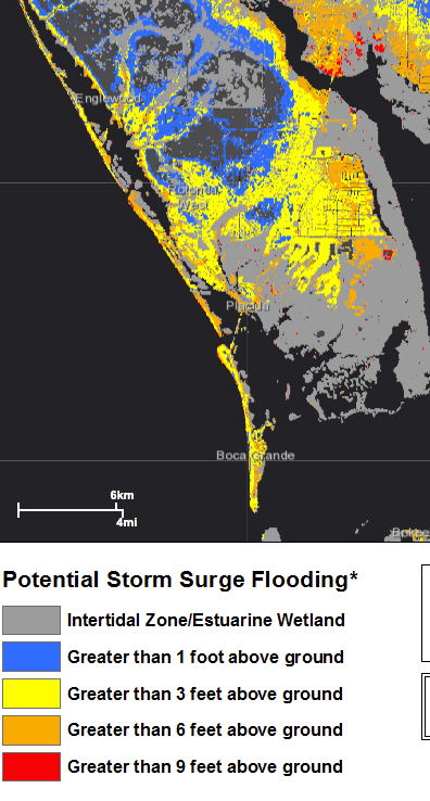
In our area if you live on the barrier islands, especially those other than Gasparilla Island, you are going to have to expect some overwashing. It may not come and that would be great, but expect it. If you live on the Cape Haze Peninsula, know your flood zone so you have a general idea of what to expect. The further south you are, the more you need to watch the water, and not just the water in Charlotte Harbor because all of those water bodies are connected in some form or fashion.
If you go outside during the storm or after and let your pets play in the water, remember there could be gators and snakes in there … not to mention fire ants seeking higher ground.
Let’s see what Tuesday morning weather reports bring and go from there.
Saturday, Sept. 23 2000 EDT
8:00 PM EDT Sat Sep 24
Location: 14.6°N 77.1°W
Moving: W at 14 mph
Min pressure: 1002 mb
Max sustained: 45 mph
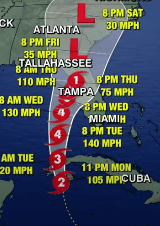
TS Ian was too slow to get the Hermine name, but now Hermine is weakening and Ian is getting stronger. We will see how slow he really is in the next two days, as he could very well hit Cuba midday Monday through Tuesday. The system is likely to strike the western part of Cuba as a major Category 3 hurricane, packing wind gusts in excess of 120 mph (190 km/h).
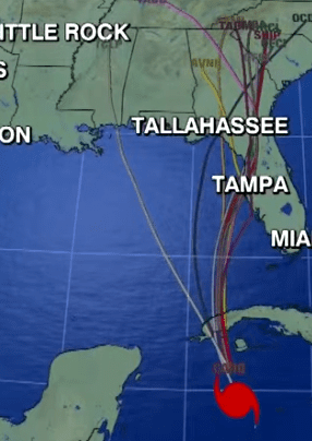
After striking Cuba, things will get tricky. The exact track of Ian across the eastern Gulf of Mexico will be determined by a southward dip in the jetstream. An area of high pressure that extended from the central Atlantic to the southern Plains of the U.S. Friday could split and allow the system to move northward. If it does, that will leave an opening for a southward dip in the jetstream to push the system to the north or northeast, and the speed of that feature will be key in determining the exact trajectory.
Long story short, we really won’t know anything until late Monday or early Tuesday. If it does skirt our coast 30 miles or more out, we could get anything from gusty wind and a few inches of rain to … not much at all. If Ian really gets to hustling once it crosses over Cuba he could fight with the jetstream and come in closer, but as a much weaker storm. If the high pressure area up north of us doesn’t split, Ian could come at us with all of his vengeance.
Right now there are models that show Ian strengthening to a Cat 4 at some point when he’s nearing parallel latitudes with Southwest Florida out in the Gulf, but that’s all speculation right now as well.
What I can tell you is this: If you couldn’t find gas today, try cruising the gas stations late at night. A lot of them get refueled during the wee morning hours.
If you’re one of the people who are filling every possible container with gas … we aren’t a fan of you. Make sure you are only using containers that specify that they can store fuel or you are going to have a mess on your hands real soon. Even in appropriate containers, pure gas begins to degrade and lose its combustibility as a result of oxidation and evaporation in three to six months. Ethanol-gasoline blends have a shorter shelf life of two to three months. So if you’re hoarding gas so people who have to go to work can’t get gas right now, we hope you use up your vast supply in a timely manner.

Bottled water supplies are also very hard to find right now. You can freeze tap water in used water bottles, which will not only serve as drinking water if there is no power or there is a boil water notice (which often happens when a big storm hits), but will keep your freezer food colder, longer. If by some longshot we are hit with a big storm that does a lot of damage, the National Guard will be here usually within three or four days and they hand out water rations as well. So slow your row, folks. Chances are, you’re going to be fine. Unless you have a huge family, buying five or six 24-packs right before a hurricane is approaching is not fair to the rest of us and is more than likely unnecessary.
We will keep you posted sporadically until Monday or Tuesday, and we will pass along any pertinent information that comes from local, state or federal government agencies. So keep your cool at the pump, start filling some plastic bottles or jugs and stick them in the freezer, buy some charcoal to cook out with and chilllll. Like the Fonz.
Friday, Sept. 23 1000 EDT
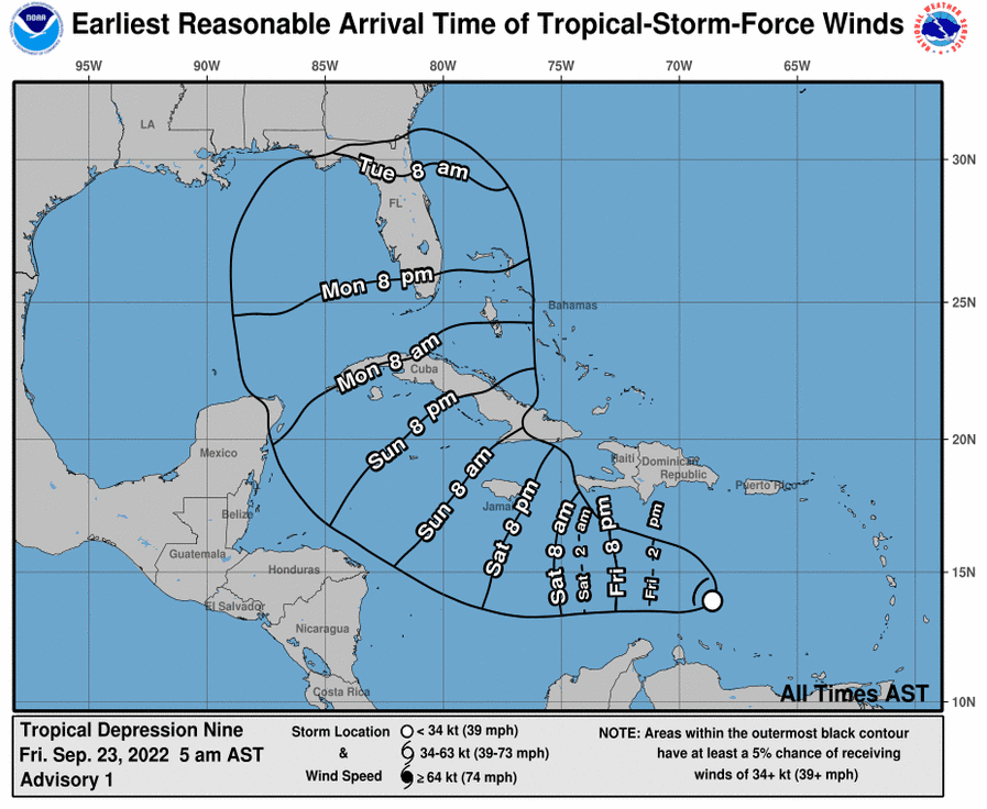
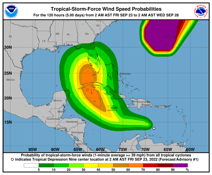
Waking up this morning we find Tropical Depression 9 still stutter-stepping around off the coast of South America, being pushed around by some disruptive wind currents. It is still expected to make it to warmer central Caribbean waters, where it will gather strength and get away from major land masses.
Projected models show it to still have a generalized projected path that could affect our area. We have attached a couple of maps from the National Hurricane Center that show what days would be the ones we would be affected if it continues on with its expected life expectancy.
It might be given a promotion to the level of tropical storm today or tomorrow, then strengthen into a hurricane we would call Hermine.
At this time, if all the apples fall from the tree the way the meteorologists are hypothesizing, this storm would be a 1 or a 2 when and if it came close to Florida’s Gulf Coast. There are models who put it at a 3 for a short period of time near our coast.
All of this could change at a moment’s notice, but the reason we’re telling you all this is so you can start the initial steps of hurricane preparedness if you have not already. That includes checking your pantry stocks to see what non-perishable foods you have, checking on battery supplies for flashlights and radios, making sure your medication refills are as up to date as possible, checking to make sure your generator starts (if you have one) and making sure your car is maintained and ready to go. That’s it.
If everyone did these things in stages instead of all at once a couple of days before a hurricane hit, we wouldn’t have to deal so much with gas and food shortages. But we digress, as we know there are plenty of people who will continue to deny a storm is coming until it is on top of them, and that it is all media hype … but then they will be the ones shouting loudest when there is chaos at the pump or the Publix.
Thursday, Sept. 22
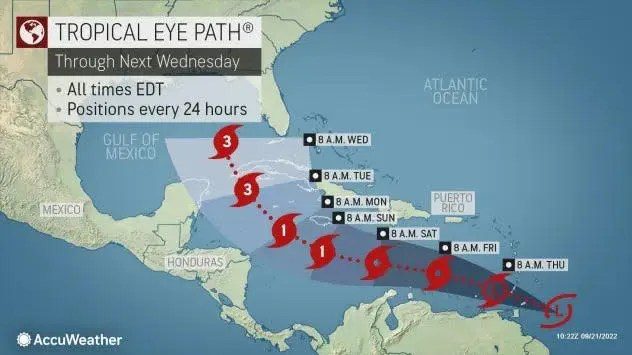
A developing tropical system could spin up into a hurricane in the Gulf of Mexico by the middle of next week, forecasters warned Wednesday.
“This is the most significant threat for the U.S. mainland we’ve had this hurricane season,” AccuWeather chief meteorologist Jonathan Porter said.
The system, known now as Invest 98L, was located near the northeastern coast of South America on Wednesday.
An “Invest” is an area that the National Hurricane Center is watching closely with advanced computer models and other resources, including the Hurricane Hunters, for possible development, according to Weather.com.
The forecast track of a tropical wave shows it strengthening into a hurricane in the Gulf of Mexico by the middle of next week.
Most computer models predict the system will be a tropical storm by the weekend in the Caribbean. The models then show the system strengthening into a hurricane by early next week. If it becomes a named storm, it would be called Hermine.
According to Weather.com, the majority of computer forecast models curl the system – probably at hurricane strength – northward into the Gulf of Mexico around the middle of next week.