


Marine rescue system MERT assists with boaters in distress

When marine emergencies require a multi-agency approach, Lee County’s Marine Emergency Response Team, or MERT, provides vital communication among agencies.
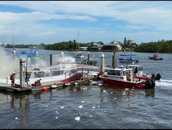
On June 22, there were multiple marine emergencies at once, including an overturned boat and a propeller strike (See “Propeller strike highlights dangerous boating weekend” in the June 28 edition of the Beacon). In a situation such as this, MERT facilitates a speedy response time with streamlined coordination between departments and agencies.
Chief Marc Mascarelli, of Useppa Island Fire Rescue, heads up the MERT team, which comprises a collection of agencies and fire departments in Lee County. In the mid-1990s, a few of the departments began adding fire boats to their fleets, so they started to coordinate with the Coast Guard, Mascarelli said.
As time went on, more boating accidents were occurring and because Lee County is broken up into 22 different fire departments, there needed to be a system of coordination, he said – “We all have to be playing off the same sheet of music.”
Part of that coordination that is made possible through MERT is the implementation of the same standard equipment, as well as a common radio channel that is accessed by all the relevant parties.
Mascarelli works as a liaison between fire departments, the Coast Guard, the Florida Fish and Wildlife Conservation Commission and even towing companies.
When a marine emergency call comes in, it is either by cell phone, radio or emergency locating beacons. The Coast Guard can then activate MERT so that a text is sent out detailing the emergency and location to the correct responders. This limits the delay of one dispatch center having to call another.
Useppa Island Fire Rescue photos
The location of an emergency is communicated through a grid system, which was originally the idea of the Boca Grande Fire Department. Latitude and longitude numbers can be too long and complicated to type in, Mascarelli said, so Chief C.W. Blosser and the BGFD thought of using a grid in order to more quickly send information, especially to responders who are unfamiliar with Gasparilla Island.
“We literally drew lines with rulers and made big maps to grid all of the water between here and the end of Lee County,” Blosser said. “The next MERT meeting, I took all of these big pieces of paper.”
From there it was given to Amy Hoyt, Lee County’s Geographic Information System (GIS) Manager, and she built an entire application for the grid, Blosser said.
There are 99 squares in the grid, with each square encompassing one square mile, and the center of each square has a GPS coordinate.
This grid system has been so successful that it has been implemented in surrounding counties, and there has been interest state-wide. Mascarelli is currently working on a similar system in the Keys, where slow or complicated emergency responses have often ended fatally.

